

The much-anticipated El Niño has arrived, and it is already meeting expectations.
Earlier this spring, climate researchers predicted the emergence of an El Niño in the central Pacific region.
As the months went by, an increasing number of models suggested that this El Niño could be particularly intense, often referred to as a “super” El Niño. However, experts cautioned that it was premature to make definitive conclusions.
In its June monthly update, the U.S. National Oceanic and Atmospheric Administration (NOAA) issued an advisory about El Niño, confirming the presence of warmer temperatures in the specific area of the Pacific Ocean designated as Niño 3.4.
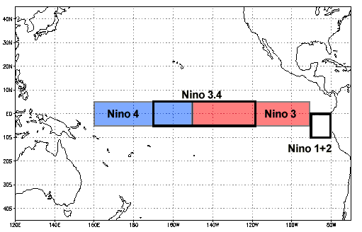
This illustration shows the Niño regions in the Pacific Ocean. (NOAA)
For an event to qualify as an El Niño, temperatures in that area must exceed the average by 0.5°C.
Currently, ocean temperatures are nearing 2°C above average, and we have yet to reach the peak.
This year marks the warmest recorded temperatures in that region for this time of year.
“In the traditional Niña 3.4 area, we’re slightly above 2°C, which is generally recognized as the threshold for a very strong or, as some might say, super El Niño,” stated Zeke Hausfather, a climate scientist with Berkeley Earth, a non-profit organization focused on climate analysis.
“So, effectively, we are already approaching very strong El Niño conditions, and it’s still early July.”
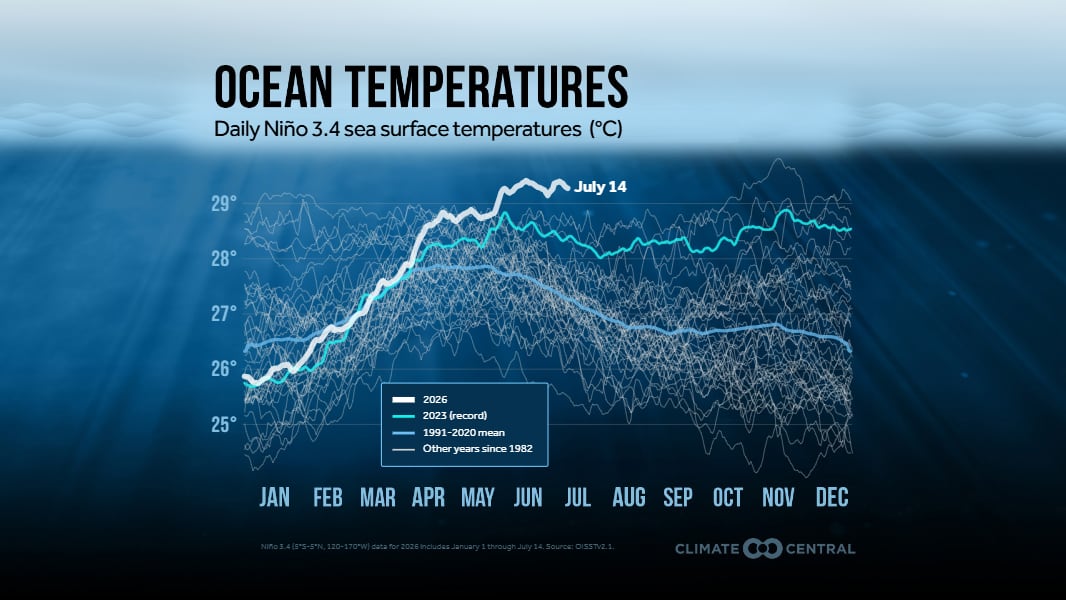
This graphic illustrates the rapid rise of sea surface temperatures in the Niño 3.4 region in the Pacific Ocean. (Climate Central)
El Niño and La Niña are components of a larger natural cycle known as the El Niño Southern Oscillation (ENSO), which occurs in a specific section of the Pacific Ocean.
While La Niña brings cooler conditions to that region, El Niño results in warmer temperatures.
Hausfather noted that some forecasts predict the peak of the El Niño will occur in October, but most models indicate it is more likely to peak in November or December.
“So we still have a long way to go. We are already nearing super El Niño territory, and we may very well be navigating uncharted waters later this year,” he remarked.
“We might end up surpassing the previous El Niño record by an astonishing margin.”
‘El Niño is no joke’
The most powerful El Niño in recent history occurred during 2015-2016, with an ocean temperature anomaly of about 2.75°C. It is believed that a comparable event took place in 1877-1878.
Nat Johnson, a meteorologist at NOAA’s geophysical fluid dynamics laboratory, mentioned that the transition from La Niña to El Niño has been remarkably swift.
“Last winter, we experienced La Niña, which resulted in cooler than average conditions in the eastern equatorial Pacific. Now, with a very strong El Niño forecast, that’s a significant shift within a single year,” he explained. “The reason for such a dramatic change this year remains an open question.”
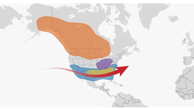
Some climate models predict 2026 will be an El Niño year — and that it’ll be a particularly strong one. CBC’s Nick Logan breaks down what that means, and what Canadians can expect.
Hausfather indicated that when models first suggested the possibility of an El Niño reaching 4°C above average, he thought they were incorrect. However, as the months have passed, this possibility seems more plausible.
“The fact that models are currently predicting a peak around 3.6°C, while the strongest El Niño on record, including arguably the one from the late 1800s, was only 2.75°C, is quite astonishing.”
Could this phenomenon be related to climate change?
Johnson stated that, although there have been fewer neutral years in the Niña 3.4 area and larger fluctuations between El Niños and La Niñas, it remains unclear if or how climate change could influence this cycle.
“It’s still a subject where I believe we have yet to reach a scientific consensus.”
-
Here’s why you don’t need to worry about a ‘super’ El Niño — yet
-
Are we in for a super El Niño this year? Early projections say maybe, and this worries climate scientists
Hausfather is particularly concerned about food security in tropical areas, especially in light of ongoing geopolitical tensions, as these regions are expected to experience drought in the coming months.
In Canada, the effects will manifest during winter, bringing warmer temperatures but also drier conditions, which raises significant concerns for wildfire risks in the spring in Western Canada.
“I think we should brace ourselves for considerable impacts,” Hausfather warned. “El Niño is serious, affecting agriculture, the natural environment, and ocean ecosystems.”